
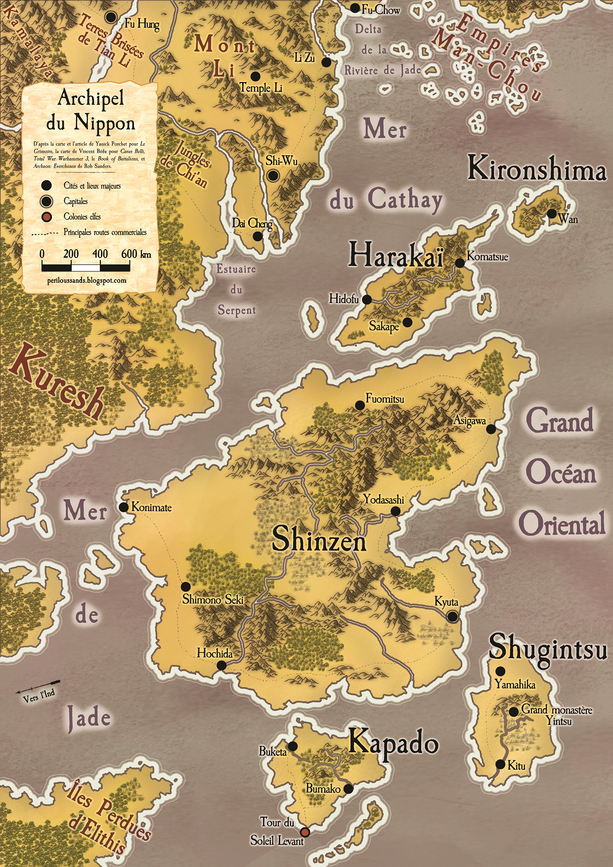
Aujourd'hui, une petite carte pour une terre quasi inexplorée du monde de Warhammer, le Nippon. Je pourrais en fait dire totalement inexplorée car en effet, malgré des mentions régulières et plusieurs listes d'armées dans les premières versions de Warhammer Battle, le Nippon n'a fait l'objet d'aucune description officielle, au delà d'une ou deux lignes. Il n'y a pas non plus de mention de lieux, ou presque. J'ai regroupé pour cette carte divers éléments, à partir des sources mentionnées dans la légende et que je détaillerai ici.
 |
| Le Grimoire N°8 |
 |
| Citadel Journal - 1985 |

 |
| Le Grimoire N°8 |
On ne reviendra pas sur Kuresh et les Îles Perdues d'Elithis qui figurent sur toutes les cartes du monde depuis Warhammer Battle v6. Pour le reste, tout ce qui figure sur la carte concernant Cathay vient de Total War Warhammer 3, sans exception. Les éléments géographiques comme les fleuves et les montagnes ainsi que les toponymes ont été réadaptés à la carte de Warhammer Battle, de la même façon que ceux de Nippon issus du Grimoire. Les forêts, reliefs et zones marécageuses du Nippon sont un composé des différentes cartes officielles ainsi que de la carte du Grimoire, avec l'ajout du marais au centre de Kapado qui ne figurait pas sur la carte mais est présenté dans l'article comme la seule région dangereuse de l'île, aussi mystérieuse que crainte par les habitants en raison des bêtes qui y rôdent. On mentionnera également qu'Asigawa, que j'ai placé arbitrairement sur l'île de Shinzen, est mentionné dans le vénérable Book of Battalions, une unité de moines combattants en étant visiblement issus.
 |
| Archaon : Everchosen - Rob Sanders |
La carte dans sa résolution maximale se trouve sur la page consacrée.
-------------------------------------------------------------

Today, a small map for an almost unexplored land of the Warhammer world, the Nippon. I could actually say totally unexplored because indeed, despite regular mentions and several army lists in the early versions of Warhammer Battle, Nippon has not been officially described in more than one or two lines. There is also little or no mention of locations. I have gathered various elements for this map, from the sources mentioned in the legend, which I will detail here.
|
| Le Grimoire N°8 |
It is an issue of Le Grimoire, a French fanzine dedicated for a while to Warhammer (out of 20 issues, no less!), that made me want to make it. It's from these pages dedicated to Nippon that most of the elements about the archipelago come from.
The names of the main islands, Shinzen, Shugintsu, Kapado and Harakaï, come from Grimoire #8, as well as almost all the cities that make it up and that appear on the map accompanying the article. Two toponyms from the same # do not appear on the map but in the article: the Great Yintsu Monastery, which is mentioned as being in the middle of Shugintsu, and Shimono Seki, which mark the geographical limit of southern Nippon. Without specifying its nature, I have made it a locality or place of interest here. It is said that from Shimono Seki onwards, Nippon enjoys a tropical and almost paradisiacal climate, which becomes more temperate as one moves northwards. Harakai is described as suffering from very harsh living conditions, and only conifers and very hardy low plants grow there.
|
| Citadel Journal - 1985 |
Comparing the Grimoire map with the official maps, we can see that one island is not at all in the right place, but this was not always the case: the map of the 1985 Second Citadel Journal, shown here, does contain an island to the east of the main island, but no second island to the north! This map combines the two elements, always assuming that ancient geography is imprecise, as I have already mentioned in other articles devoted to this theme. This fifth island is the result of the splitting of the northernmost of the four original islands, from the Warhammer Battle v6 map available in a White Dwarf. It is therefore not named by the Grimoire because it did not exist at the time. This is an opportunity to say that the map as a whole is based on the map shown below, and I'm adding a little overlay to show you the orientation!
|
| Le Grimoire N°8 |
You'll notice that I've largely reoriented the map to allow for more geographical context, in this case Cathay and Kuresh. And a bit of Ind too, with the mention of the Kamalaya range, which comes from an article in Casus Belli, already covered elsewhere! I realised a bit late that the two maps would meet around Fu Hung, so I might as well show how the two geographical areas relate to each other. This brings us to the other sources. For if the Grimoire names islands and cities, not all the toponyms come from it.
We won't talk about Kuresh and the Lost Islands of Elithis, which have appeared on all the world maps since Warhammer Battle v6. For the rest, everything on the map concerning Cathay comes from Total War Warhammer 3, without exception. Geographical elements such as rivers and mountains as well as place names have been adapted to the Warhammer Battle map, in the same way as those of Nippon from the Grimoire. The forests, landforms and swampy areas of Nippon are a composite of the various official maps as well as the Grimoire map, with the addition of the swamp in the centre of Kapado which was not on the map but is presented in the article as the only dangerous area of the island, as mysterious as it is feared by the inhabitants because of the beasts that prowl around it. It should also be mentioned that Asigawa, which I arbitrarily placed on the island of Shinzen, is mentioned in the venerable Book of Battalions, a unit of warrior monks apparently coming from there.
|
| Archaon : Everchosen - Rob Sanders |
For the rest, let's specify that the Jade Sea comes from Total War Warhammer 3, the Sea of Cathay from Le Grimoire, and that the Man-Chou Empires (yes, empires in the plural) are mentioned in the novel Archaon: Everchosen by Rob Sanders, a good part of which takes place in the Great Eastern Ocean. They seem to have originated from the tribes residing in the steppes north of Cathay, but the novel makes it clear that they are maritime empires of raiders. Interestingly, the Grimoire mentions numerous small islands in the Sea of Cathay and countless kingdoms located there. The opportunity is too good, and I have here sort of extended the peninsula of which we see a part in the north of the map: in Total Warhammer 3 it is quite large, and I apply here a principle already mentioned elsewhere: cartographers will not necessarily distinguish between a landmass and an archipelago, if they do not explore it closely. Moreover, this peninsula is not protected by the wall that cuts Cathay off from the steppes, and it is therefore quite possible that tribes have used it to swarm out to sea. The same novel mentions in the same sentence the Nipponese pirates of the Kironshima Wan. I have chosen here to interpret the English sentence as "the Nipponese pirates of Wan, the one from Kironshima", thus giving a name to the famous fifth island in the north of Nippon and to an important city. The geographical proximity is somehow justified by the thematic proximity of the novel.
Hopefully this map will give ideas to explorers!
The map in its maximum resolution can be found on the dedicated page.
Toujours un plaisir de te voir retconer plein de trucs ! J'avoue être surpris que les vieilles cartes ne se soient pas contentées de carrément donner une apparence plus "visiblement japonaise" à la grosse île, plus en forme de banane. Même si les noms donnent le ton (Kironshima, hum...)
RépondreSupprimerAh ça, les toponymes infâmes, ça fait partie intégrante de l'univers !
SupprimerPour la géographie générale de Nippon, les vieilles cartes justement, même si on reconnait très bien les formes générales des continents ou de régions spécifiques, n'ont jamais été des copiés collés absolus, et heureusement ! Il y a toujours des variations de taille et de forme, suffisamment pour ne trop faire tiquer. Je mettrait un bémol pour la Lustrie qui est bien souvent trop proche de l'Amérique du Sud à mon goût, et la première carte d'Albion qui pour le coup évoque de façon bien plus (trop ?) les îles britanniques.
Toutes les "Amériques" sont un peu trop voyantes, je trouve, mais c'est vrai qu'en général, même si on reconnaît bien, y a un effort de déformation... cela dit, le Nippon ne ressemble vraiment pas du tout au Japon (et je trouve ça très bien, hein !)
Supprimer